A World Bridge® Labs
A World Bridge® Labs is a new website where project application development is showcased. The current projects feature data visualization utilizing the NASA World Wind geospatial 4D platform.
NASA World Wind is a free, open source API for a virtual globe. World Wind allows developers to quickly and easily create interactive visualizations of 3D globe, map and geographical information. Organizations across the world use World Wind to monitor weather patterns, visualize cities and terrain, track the movement of planes, vehicles and ships, analyze geospatial xdata, and educate people about the Earth.
Site: A World Bridge® at Northern Academy, Middletown, NY
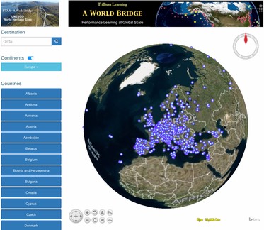
Project: United Nations Educational, Scientific and Cultural Organization (UNESCO) World Heritage Site
Description: New York’s Northern Academy, Middletown, NY – A World Bridge® students are making a visit to any UNESCO World Heritage site as easy as it is informative. While viewing the Earth from space, all World Heritage sites are visible. With just a click you zoom from a satellite view right to the World Heritage site, and easily access all the culturally rich information for that site.
As part of this effort, the students have carefully analyzed all the UNESCO World Heritage site data. By cross-checking with multiple quality assurance/quality control (QA/QC) procedures, they have identified and corrected several location errors, where the site is not located where it is supposed to be.
Enjoy access to the World Heritage sites by continent, country and other criteria. Each World Heritage placemark is interactive, displaying a dialog box with a summary of site information, and links to the UNESCO website.
Project link: http://whs.aworldbridgelabs.com/
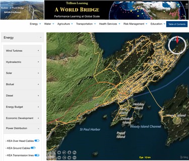
Site: A World Bridge® at Northern Academy, Middletown, NY in Collaboration with Kodiak, Alaska
Project: CitySmart - WorldWise
Description: New York’s Northern Academy, Middletown, NY in collaboration with students from Kodiak, Alaska – A World Bridge® students are developing a CitySmart web app that visualizes the entire infrastructure for a city. All the power lines, water, sewer, communication and roads, etcetera, are mapped accurately including all databased information about each item, i.e., transmission pole, manhole cover, road location, etc.
Project link: http://cs.aworldbridgelabs.com
Site: A World Bridge® at Kodiak Island Borough School District
Project: Earthquake Signal Precursors
Description: Students acquire precursor earthquake data from sensor arrays and develop real-time data visualization models utilizing NASA WebWorldWind. The data server resides within A World Bridge® Project server in Kodiak, Alaska. This team is developing ground station technology platforms, which acquire continuous magnetic field information at 50Hz from remote locations.
Data acquisition stations continuously transmit data to servers designed to record, visualize, and archive this data. Data visualization events represent 3-axis precursor magnetic anomalies as dynamic vectors, providing advanced warning via anomaly detection algorithms for specific areas of increasing tectonic plate stress. Visualizations are then accessible through the ESP NASA World Wind application.
Project link: http://esp.trilliumlearning.com/